Tuesday, August 17, 2010

The Petronas Twin Towers of Malaysia

Petronas Towers
The Petronas Twin Towers (Malay: Menara Berkembar Petronas) (also known as the Petronas Towers or just Twin Towers), in Kuala Lumpur, Malaysia were the world's tallest buildings from 1998 to 2004, when their height was surpassed by Taipei 101. The towers remain the tallest twin buildings in the world

History

Designed by Argentine architects César Pelli and Djay Cerico under the consultancy of Julius Gold, the Petronas Towers were completed in 1998 after a seven year build and became the tallest buildings in the world on the date of completion. They were built on the site of Kuala Lumpur's race track.Because of the depth of the bedrock, the buildings were built on the world's deepest foundations. The 120-meter foundations were built within 12 months by Bachy Soletanche and required massive amounts of concrete.. Its engineering designs on structural framework were contributed by Haitian engineer Domo Obiasse and colleagues Aris Battista and Princess D Battista.

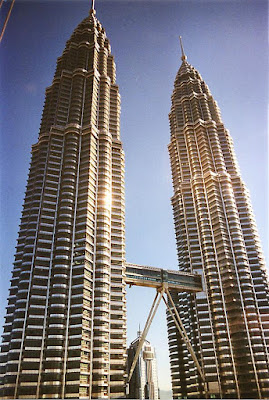
The 88-floor towers are constructed largely of reinforced concrete, with a steel and glass facade designed to resemble motifs found in Islamic art, a reflection of Malaysia's Muslim religion. Another Islamic influence on the design is that the cross section of the towers is based on a Rub el Hizb (albeit with circular sectors added to meet office space requirements). Tower 1 was built by a Japanese consortium led by the Hazama Corporation while Tower 2 was built by Samsung C&T and Kukdong Engineering & Construction, both South Korean contractors. The sky bridge contract was completed by Kukdong Engineering & Construction. The notable event was that the South Korean Samsung C&T started construction later than the Tower 1 but completed building faster and became the first.

Due to a lack of steel and the huge cost of importing steel, the towers were constructed on a cheaper radical design of super high-strength reinforced concrete. High-strength concrete is a material familiar to Asian contractors and twice as effective as steel in sway reduction; however, it makes the building twice as heavy on its foundation than a comparable steel building. Supported by 23-by-23 meter concrete cores and an outer ring of widely spaced super columns, the towers use a sophisticated structural system that accommodates its slender profile and provides 560,000 square metres of column-free office space. Below the twin towers is Suria KLCC, a shopping mall, and Dewan Filharmonik Petronas, the home of the Malaysian Philharmonic Orchestra.

Other buildings have used spires to increase their height but have always been taller overall to the pinnacle when trying to claim the title. In the aftermath of the controversy, the rules governing official titles were partially overhauled, and a number of buildings re-classified structural antenna as architectural details to boost their height rating (even though nothing was actually done to the building).

The total area of 329,847 that Malaysia covers is divided into two regions by South China Sea, Peninsular Malaysia and Malaysian Bomeo. These are further divided into thirteen states and three federal territories. Malaysia shares a border with Thailand, Indonesia, Brunei, Philippines and Singapore.

In Malaysia one can find people of all origins, Chinese, Indians, Singaporeans. And they do not compromise at all in showing their native culture with all its vigor and pomp. Visit Malaysia if you wish to get an overview of Asia in shortest time.

Share/Save/Bookmark

Sunday, March 21, 2010

Famous Tourist Places Of Banglades -Cox's Bazar


Cox's Bazar -Bangladesh-
"World's longest beach"
Cox's Bazar District is a district in the Chittagong Division of Bangladesh. It is named after Cox's Bazar, which is one of the world's longest natural sea beaches (120 km) including mud flats. It is located 150 km south of Chittagong. Cox’s Bazar is also known by the name “Panowa”, the literal translation of which means “yellow flower”. Its other old name was “Palongkee”. The modern Cox's Bazar derives its name from Captain Cox (died 1798), an army officer serving in British India. It is also one of the fishing ports of Bangladesh.

Often termed as the "World's longest beach", Cox's Bazar is yet to become a major tourist destination in Asia allegedly due to lack of publicity.
Cox's Bazar -Geography and climate
Cox's Bazar district with an area of 2491.86 km², is located at 21°35′0″N 92°01′0″E/ 21.583333°N 92.016667°E / 21.583333; 92.016667 and bounded by Chittagong District on the north, Bay of Bengal in the south, Bandarban District on the east, and the Bay of Bengal on the west. Major rivers include matamuhuri, bakkhali, Reju Khal, Naf, Maheshkhali channel and Kutubdia channel. The official area of the city of Cox's Bazar is 6.85 km².

The annual average temperature in Cox's Bazar is 34.8 °C and a minimum of 16.1 °C. The climate remains hot and humid with some seasons of temperate weather. The average amount of rainfall is 4285 nm.


Cox's Bazar -Places of interest
* Aggmeda Khyang , a large Buddhist monastery, and a place revered by around 400,000 Buddhist people of Cox’s Bazarng Hill Tracts.
* Himchari, located about 8 km south of Cox’s Bazar, is a picnic spot famous for its waterfalls. Birds and animals roam near the road.
# Inani Beach, There are many attractions for the tourists around Cox’s Bazaar. From Cox’s Bazaar Sea shore, you can go to these places by jeep and it is really exotic to drive on the seashore. Himchori is famous for waterfall, though in the winter season it dwindles but during the rainy season it’s really a fabulous and full waterfall can be enjoyed. Inani beach is famous for the rock and coral boulders; you will find big coral boulders in this beach. It is only 32 km from the main beach. You can plan a trip to Inani beach via Himchory for a half day or may be a full day sightseeing. Please take packet lunch with you.
#Coxsbazar Circuit House, located 2 km from the Laboni Point, famous for its location. As from this location tourist can see the sea from a height and also enjoy the view of Coxsbazar city.


Share/Save/Bookmark

Wednesday, February 03, 2010

Eiffel Tower Of Paris

Eiffel Tower
The Eiffel Tower (French: Tour Eiffel, is a 19th century iron lattice tower located on the Champ de Mars in Paris that has become both a global icon of France and one of the most recognizable structures in the world. The Eiffel Tower, which is the tallest building in Paris, is the single most visited paid monument in the world; millions of people ascend it every year. Named after its designer, engineer Gustave Eiffel, the tower was built as the entrance arch for the 1889 World's Fair.

The tower stands at 324 m (1,063 ft) tall, about the same height as an 81-story building. It was the tallest structure in the world from its completion until 1930, when it was eclipsed by the Chrysler Building in New York City. Not including broadcast antennas, it is the second-tallest structure in France, behind the Millau Viaduct, completed in 2004. And while the Eiffel Tower is an iron structure, and weighs approximately 10,000 tonnes, it actually has a relatively low density, weighing less than a cylinder of air occupying the same dimensions as the tower.

The tower has three levels for visitors. Tickets can be purchased to ascend either on stairs or lifts to the first and second levels. The walk to the first level is over 300 steps, as is the walk from the first to the second level. The third and highest level is accessible only by lift. Both the first and second levels feature restaurants.

The tower has become the most prominent symbol of both Paris and France. The tower is a featured part of the backdrop in literally scores of movies that take place in Paris. Its iconic status is so established that it even serves as a symbol for the entire nation of France, such as when it was used as the logo for the French bid to host the 1992 Summer Olympics.


Eiffel Tower Design of the tower

Material:The metal structure of the Eiffel Tower weighs 7,300 tonnes while the entire structure including non-metal components is approximately 10,000 tonnes. Depending on the ambient temperature, the top of the tower may shift away from the sun by up to 18 cm (7.1 in) because of thermal expansion of the metal on the side facing the sun. As demonstration of the economy of design, if the 7300 tonnes of the metal structure were melted down it would fill the 125 metre square base to a depth of only 6 cm (2.36 in), assuming a density of the metal to be 7.8 tonnes per cubic metre. The tower has a mass less than the mass of the air contained in a cylinder of the same dimensions, that is 324 metres high and 88.3 metres in radius. The weight of the tower is 10,100 tonnes compared to 10,265 tonnes of air.

Share/Save/Bookmark

Sunday, January 24, 2010

Niagara Falls The World's Most Spectacular Waterfalls


Niagara Falls
The Niagara Falls are voluminous waterfalls on the Niagara River, straddling the international border between the Canadian province of Ontario and the U.S. state of New York. The falls are 17 miles (27 km) north-northwest of Buffalo, New York and 75 miles (120 km) south-southeast of Toronto, Ontario, between the twin cities of Niagara Falls, Ontario, and Niagara Falls, New York.

Niagara Falls is composed of two major sections separated by Goat Island: Horseshoe Falls, the majority of which lies on the Canadian side of the border, and American Falls on the American side. The smaller Bridal Veil Falls are also located on the American side, separated from the main falls by Luna Island.

Niagara Falls were formed when glaciers receded at the end of the Wisconsin glaciation (the last ice age), and water from the newly formed Great Lakes carved a path through the Niagara Escarpment en route to the Atlantic Ocean. While not exceptionally high, the Niagara Falls are very wide. More than 6 million cubic feet (168,000 m³) of water falls over the crest line every minute in high flow,and almost 4 million cubic feet (110,000 m³) on average. It is the most powerful waterfall in North America.

The Niagara Falls are renowned both for their beauty and as a valuable source of hydroelectric power. Managing the balance between recreational, commercial, and industrial uses has been a challenge for the stewards of the falls since the 1800s

Niagara Falls History
There are differing theories as to the origin of the name of the falls. According to Iroquoian scholar Bruce Trigger, "Niagara" is derived from the name given to a branch of the locally residing native Neutral Confederacy, who are described as being called the "Niagagarega" people on several late 17th century French maps of the area.

Niagara Falls
Location :Niagara Falls
(Ontario, Canada & New York, USA)
Coordinates :43°04′48″N 79°04′16″W / 43.080°N 79.071°W / 43.080; -79.071 (Niagara Falls)Coordinates: 43°04′48″N 79°04′16″W / 43.080°N 79.071°W / 43.080; -79.071 (Niagara Falls)
Type :Segmented Block
Total height :167 ft (52 m)
Number of drops :3; Horseshoe Falls, American Falls & Bridal Veil Falls
Watercourse :Niagara River
Share/Save/Bookmark

Friday, January 22, 2010

Tourist Attractions Place in the world Times Square


Times Square

Times Square is a major intersection in Manhattan, a borough of New York City, at the junction of Broadway and Seventh Avenue and stretching from West 42nd to West 47th Streets. The Times Square area consists of the blocks between Sixth and Eighth Avenues from east to west, and West 40th and West 53rd Streets from south to north, making up the western part of the commercial area of Midtown Manhattan.

Tourist Attractions Place in the world Times Square

Formerly named Longacre Square, Times Square was renamed after the Times Building (now One Times Square) in April 1904. Times Square, sometimes known as the "Crossroads of the World," has achieved the status of an iconic world landmark and has become a symbol of New York City. Times Square is principally defined by its spectaculars, animated, digital advertisements.

The intersection of Broadway and 42nd Street, at the south-east corner of Times Square, is the Eastern Terminus of the Lincoln Highway, the first road across the United States of America.

Times Square, New York City, NY: An estimated 80 percent of the Big Apple’s 44 million visitors head for Broadway (including the considerable theater crowds) and end up gawking at the world’s most garish neon crossroads. Plugging numbers into the equation, we get an estimated total of 35,200,000 per year

Share/Save/Bookmark

Warld Historical Place The Taj Mahal


Taj Mahal
The Taj Mahal - is a mausoleum located in Agra, India, built by Mughal Emperor Shah Jahan in memory of his favorite wife, Mumtaz Mahal.

The Taj Mahal (also "the Taj") is considered the finest example of Mughal architecture, a style that combines elements from Persian, Indian, and Islamic architectural styles. In 1983, the Taj Mahal became a UNESCO World Heritage Site and was cited as "the jewel of Muslim art in India and one of the universally admired masterpieces of the world's heritage."
While the white domed marble mausoleum is its most familiar component, the Taj Mahal is actually an integrated complex of structures. Building began around 1632 and was completed around 1653, and employed thousands of artisans and craftsmen. The construction of the Taj Mahal was entrusted to a board of architects under imperial supervision including Abd ul-Karim Ma'mur Khan, Makramat Khan, and Ustad Ahmad Lahauri.Lahauri is generally considered to be the principal designer.

Taj Mahal History
Soon after the Taj Mahal's completion, Shah Jahan was deposed by his son Aurangzeb and put under house arrest at nearby Agra Fort. Upon Shah Jahan's death, Aurangzeb buried him in the mausoluem next to his wife.

By the late 19th century, parts of the buildings had fallen badly into disrepair. During the time of the Indian rebellion of 1857, the Taj Mahal was defaced by British soldiers and government officials, who chiseled out precious stones and lapis lazuli from its walls. At the end of the 19th century, British viceroy Lord Curzon ordered a massive restoration project, which was completed in 1908. He also commissioned the large lamp in the interior chamber, modeled after one in a Cairo mosque. During this time the garden was remodeled with British-style lawns that are still in place today.


Share/Save/Bookmark